


California.
The state of California is no stranger to wildfires, with devastating fires becoming an annual occurrence in the Golden State. However, the scale and frequency of these fires are growing, and the latest crisis of 2025 has brought renewed attention to the technological advancements that can aid in managing such disasters. Satellite technology, which has long been used in various fields, has emerged as a critical tool in tracking, understanding, and responding to the increasingly destructive wildfires. In this article, we explore five key questions about the role of satellite technology in wildfire response, shedding light on how this technology is transforming disaster management in California.
1. How Are Satellites Helping Track the Spread of Wildfires?
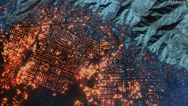
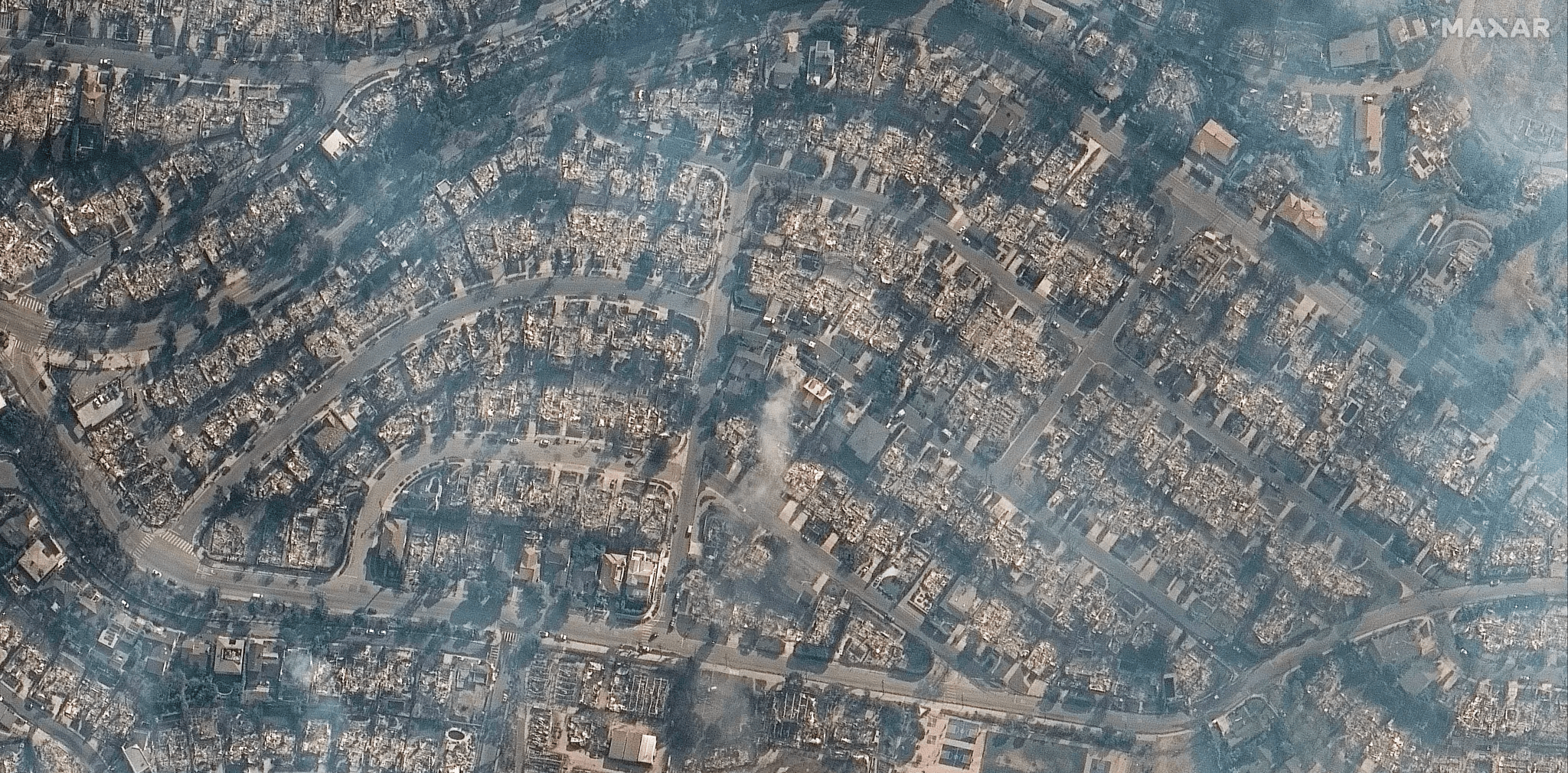
Satellite technology has revolutionized the way wildfires are monitored. Satellites equipped with advanced sensors can capture real-time images of the fire’s progress, including the affected areas, terrain, and speed of the fire’s spread. This ability to view the fire from above offers an unparalleled vantage point, allowing firefighting agencies to track how the fire is advancing and where it is most likely to spread next. For example, during the 2025 California wildfires, satellites provided detailed visual data showing which neighborhoods were at risk, helping emergency response teams prioritize evacuations and resource deployment.
Moreover, California’s satellite imagery can be used to track the heat signature of wildfires, even through smoke, allowing firefighters to detect and assess fires in remote or hard-to-reach areas. This data can be shared with firefighting teams on the ground to improve their response times and effectiveness, ultimately saving lives and reducing property damage.
2. Can Satellite Technology Help Predict the Next Wildfire?
While satellites cannot prevent California wildfires from happening, they can play a crucial role in early detection and fire risk prediction. Satellite technology is used to monitor environmental conditions that contribute to fire risk, such as temperature, humidity, soil moisture, and vegetation health. By analyzing this data, experts can identify regions that are more susceptible to wildfires, allowing for targeted fire prevention measures.
Additionally, satellites are able to detect anomalies in vegetation and soil conditions, such as dry or parched land, which can indicate heightened fire risk. This predictive capability allows authorities to issue warnings to communities in advance, prepare firefighting resources in those areas, and even conduct controlled burns to reduce the risk of larger fires. By improving early detection and risk prediction, satellite technology enhances the ability of fire management teams to mitigate the impacts of wildfires before they spread uncontrollably.
3. How Accurate Are Satellite Images in Assessing Fire Damage?
One of the most significant advantages of using satellite technology in California wildfire response is its ability to assess damage across vast areas with high accuracy. Satellite images provide detailed snapshots of large swathes of land, helping experts analyze the extent of destruction caused by the fires. These images can show which areas have been completely destroyed, which areas are partially damaged, and how the fire has affected nearby infrastructure, agriculture, and natural resources.
However, the accuracy of satellite imagery in assessing fire damage depends on several factors, such as the resolution of the satellite and the time between image captures. While satellites provide valuable insights, they cannot always capture the full extent of human loss or destruction in small, isolated areas. To address this limitation, satellite data is often combined with ground reports and aerial assessments to create a more comprehensive picture of the damage. Despite these challenges, satellite technology remains an indispensable tool in understanding and responding to wildfire destruction.
4. Can Satellite Data Enhance Real-Time Emergency Response?
During active wildfires, time is of the essence, and satellite technology is crucial in providing real-time data that can guide emergency response efforts. As the 2025 fires raged across California, satellite images were updated regularly, giving authorities and firefighting teams crucial information on the fire’s location and direction. This data can be used to coordinate evacuations, allocate resources like fire engines and personnel, and even close off roads and highways to ensure public safety.
Satellites also provide critical information for the deployment of firefighting aircraft, such as water bombers, which need precise targeting to maximize their effectiveness. With the real-time data from satellites, these aircraft can be directed to areas where the fire is most intense, helping to slow its spread and protect vulnerable communities.
Furthermore, satellite data supports recovery efforts after the fire is contained. Authorities use the imagery to assess damage, prioritize areas for rebuilding, and allocate resources to those who need assistance the most. In this way, satellite technology plays an essential role not only in fighting the fire but also in the post-disaster recovery phase.
5. How Can Satellite Technology Contribute to Long-Term Wildfire Management?
While satellite technology is invaluable in responding to immediate wildfire threats, it can also contribute to long-term wildfire management and prevention strategies. Over time, satellite data helps build a better understanding of wildfire behavior, including which regions are most vulnerable to fires, how climate change is influencing fire patterns, and which mitigation efforts are most effective.
By continuously monitoring fire-prone areas, satellites allow for the development of more effective land management practices, such as controlled burns and firebreaks. In addition, satellite images can be used to monitor the health of forests and vegetation, enabling authorities to detect areas that need to be cleared or managed to reduce fire risk.
Satellite data also aids in the ongoing study of climate change and its impact on wildfires. As climate change contributes to hotter and drier conditions, which in turn increase the likelihood of wildfires, satellite data can track these trends and help policymakers adjust their approach to wildfire management and land use.
Conclusion: A Game-Changer for California’s Wildfire Response
As California continues to face the devastating impacts of wildfires, satellite technology has proven to be an invaluable tool in the fight against these destructive events. From tracking the spread of fires to assessing damage and predicting fire risks, satellites offer a powerful solution for managing wildfire crises more effectively. While no technology can entirely prevent wildfires, the integration of satellite data into firefighting and disaster response strategies is undoubtedly a game-changer for California and other fire-prone regions around the world. By leveraging this technology, authorities can not only respond more swiftly but also develop more proactive strategies for wildfire management in the future.
Also Read-
1. 10 Lives Lost: Could the Los Angeles Wildfires Have Been Prevented
2. Earth Faces 5 Critical Questions as 2024 Becomes Hottest Year Ever Recorded


2 thoughts on “California in Crisis: 5 Key Questions About the Role of Satellite Technology in Wildfire Response”